Are you looking for KCSE 2019 Kenya National Examinations Council, KNEC, Geography (312) report? Well. You can now get the KNEC report here that will enable you prepare well for this year’s examination. Get this and other KCSE reports in this site at no cost.
The year 2019 KCSE Geography examination vas presented in two papers: paper 1 (31211) covers the “Physical Geography and Map Reading” while paper 2 (312/2) examines “Human and Economic Geography, Photographic Interpretation skills and Statistics”. Each of the two papers had ten (10) questions.
This report analyses the performance of candidates in the year 2019 Geography examination papers, paying special attention to the poorly performed items. It Looks at what the questions tested, the candidates’ weaknesses and possible reasons for their poor performance. It also gives advice to Geography teachers with the aim of improving future performance in the subject.
See also; KCSE 2019 KNEC reports per subject download (All subjects included)
2.1 GENERAL CANDIDATES’ PERFORMANCE
The table below shows the overall performance in Geography over the period 2015 to 2019.
Table; candidates overall performance in Geography for the last five years

The following observations can be made from the table above:
- The candidature increased from 166,507 in 2018 to 179,843 in 2019.
- There was an improvement in the overall performance of the subject from an overall mean of 83.25 in 2018 to 93 in 2019. The overall performance of the subject was average.
- There was an improvement in performance in Geography paper one (312/1) from a mean of 37.85 in 2018 to 47 in 2019.
- The performance of Geography paper two (31212) registered an improvement in performance from a mean of 45.4 in 20 18 to 46 in 2019.
- The standard deviation in both papers, 18.549 in 312/1 and 17.088 in 312/2, shows a reasonable spread of candidates’ scores from the mean.
Despite the improved performance, some questions were performed poorly and they will he discussed in the section below.
3.2.2 Geography Paper 1 (312/1)
The performance of candidates in this paper improved from a mean of 37.85 in 2018 to 47 in 2019. The paper adequately tested the syllabus and the questions were well balanced.
This report will look at questions that registered poor performance, identify areas of weakness, the expected responses and general advice to teachers’ in order to improve performance.
The questions that were performed poorly are: Q 3, 6 c (ii) and 9 a (i) and b (ii)
Requirement Q 3; Give four proofs that support the theory of continental drift.
Weaknesses
Many candidates could only remember two proofs i.e. jig-saw fit and paleo-magnetism.
Expected responses
- Some continents seem to fit geometrically/ jigsaw fit along the coastal margins
- There are similarities between the fossils of flora and fauna found on both sides of Atlantic Ocean/ Paleontological/Paleo zoological evidence.
- Same geological structure can be traced from one continent to another.
- There are similarities in the past climate in the different parts of the world. /Falco-climatological evidence.
- There are continuous mountain ranges made up of young volcanic rocks at the mid Atlantic. The shores of Red Sea exhibits evidence of having undergone lateral displacement. /Sea floor spreading.
- Paleo magnetic evidence/minerals with same alignment are found in different continents adjacent to one another.
- Similarity of fauna/flora in different continents (Congo & Amazon).
Advice to teachers
Regular revision of the topic aided by ICT simulations would make mastery of this theory by the learners easier for the candidates_ Teachers should engage the candidates in discussions on the different proofs for better understanding of the concept_
Requirement Q 6 (cii): Explain bow the following factors have influenced the distribution of settlements in the area covered by the map.
- Transport
- Vegetation
- Relief
Weaknesses
Most of the candidates could not explain how transport, vegetation and relief have influenced settlement in the area covered by the map. Learners were not able to establish the relationship between the given factors and settlements.
Expected responses
Transport
- Along the roads/motorable tracks/footpaths. there is linear settlement.
- At road junctions there are clustered/nucleated settlements.
Vegetation
- There arc no settlements within the woodland/thickets/areas where there are papyrus swamp/ vegetation.
- Most of the areas covered by scrub/scattered trees have clustered/nucleated settlement.
Relief
– There are no/few settlements on the hills/isolated islands in the lake.
– There are clustered/nucleated settlements on the undulating land
Advice to teachers
There is need for teachers to differentiate population from settlement in the teaching of map reading skills .It is also vital that learners practice identifying the different factors that influence settlement distribution on different topographical maps.
More emphasis should be put on the interpretation skills in map reading. Simplified notes can he provided coupled with frequent practical exercises to sharpen the map reading skills.
Requirement Q 9 a (i) and b (ii)
Define an ocean
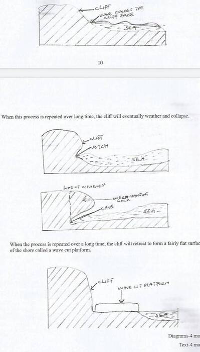
With the aid of well labelled diagrams, describe the processes through which a wave cut plat-form is formed.
Weaknesses
Many candidates could not define an ocean correctly. Some learners confused processes of wave erosion with the processes through which a wave cut platform is formed hence ended up with wrong responses.
Expected responses
- During high tides, there is undercutting at the base of the cliff by wave erosion/ forming a notch.
- Continued wave erosion enlarges the notch to form a cave.
- The hanging rocks above the cave will undergo weathering and collapse.
- When this process is repeated over long time, the cliff will eventually weather and collapse.
Advice to teachers
Teachers should teach the topics, oceans and coasts using diagrams and digital illustrations where possible to make them real to the learners. Regular testing of the topic and group discussions on the same will enable better understanding of the topics.
A field study on coastal features along the Kenyan coast will also make the topics less abstract and more enjoyable to learn.
3.23 Geography Paper 2 (312/2)
The performance of candidates in this paper registered an improvement from a mean of 45.4 in 2018 to 46 in 2019.
This report looks at question 1 (b), 7 a (ii), 8(c) and 10 a (ii) and b which presented some challenges in the way candidates answered them.
Requirement Q 1(b)
State how government policy influenced the establishment of Mwea irrigation scheme.
Weaknesses
Most candidates showed limited understanding of the influence of government policy on the establishment of Mwea irrigation scheme hence stated physical and human factors.
Expected responses
- There was need to keep detainees busy.
- For people to provide free labour.
- There was need to settle landless people.
- The need to control flood of rivers that pass through the area.
- Increase food production.
- For maximum utilization of land.
- To fully utilize the black cotton soil.
Advice to teachers
Teachers need to exhaustively discuss in details all the factors that influenced the establishment of Mwea irrigation scheme and Perkerra as well since they are case studies.
Requirement 0 7 a (Il): State five physical conditions that favour cocoa farming in Ghana.
Weaknesses
Most candidates were unable to distinguish physical conditions and human conditions that favour cocoa fanning in Ghana thus ended up mixing them up. Other candidates had limited descriptive terms for the physical conditions hence ended up with general descriptions.
Expected responses
- High and well distributed rainfall /1000-1500mm.
- High temperatures 21°C to 30PC/warm/hot conditions
- Protection from strong winds that blow away pods.
- High relative humidity.! 70%-80%
- Deep, well drained fertile/loamy soils/volcanic/lightly clay/soil rich in potassium.
- A sunny period for ripening.
- Low altitude 0-750 metres above sea level.
- Undulating landscape
- Protection of young plants from sunshine
Advice to teachers
Teachers need to clearly differentiate physical and human conditions while teaching on crop requirements.
Candidates need to be conversant with the accurate descriptive terms unique for each of the crops studied.
Requirement for 8 c: Outline ways in which wild animals are of significance to the Economy of Kenya.
Weaknesses
Some candidates gave the significance of wildlife instead of wild animals to the economy of Kenya while others were not able to clearly bring out the significance of wild animals to the economy of Kenya.
Expected responses
- They earn the country foreign exchange from tourism.
- It provides employment to the people in the national park/ tourists hotels.
- They provide game meat/food to local consumption/ export.
- National parks/game reserves are used for scientific studies and research.
- Wild animals provide a balanced ecosystem in Kenya
- They earn the government revenue.
- Some animals provide raw materials for industries.
- The conservation of wild animals stimulates development of roads/increased accessibility in some otherwise remote areas.
- Wild animals help provide alternative land use in semi-arid areas not suitable for agriculture
Advice to teachers
Teachers should encourage candidates to read and understand questions well before attempting. Learners must understand that wild animals are part of wildlife.
Requirement Q 10 a (ii) and b;
Name four types of mass communication
Explain the role of communication in the economic development of Africa.
Weaknesses
Many candidates were not able to name the types of mass communication. Most of the candidates were not conversant with the role of communication on economic development in Africa and instead focused on transportation.
Expected responses 10a) (ii)
- Radio
- Television
- Internet
- Newspapers/magazines
- Films/videos
- Billboards/banners/posters/flyers
Expected responses 10 b)
- Communication enhances trade in that traders are able to communicate to get raw materials/to sell their products.
- Many people are employed in the communication sector leading to improvement in their standards of living.
- Communication has helped in promoting international/domestic tourism leading to gain in foreign exchange/revenue.
- Governments are able to disseminate information through the media (e.g. information related to environmental conservation/ educational programmes/ for suitable economic response.
- Communication promotes international relations which enhances trade between Africa and other countries.
- Communication enhances political stability for economic growth
Advice to teachers
When teaching this topic it is important to clearly distinguish communication and transportation networks. Debates and discussions on the functions of these networks in Africa can be held after the topic in order for the learners to grasp it better
3.2-4 GENERAL COMMENTS
- Teachers should comprehensively cover the syllabus within the time allocated, marked by in-depth teaching of terms and concepts. The comparative studies outlined in the syllabus should be emphasized using approved revision Woks/Case Studies/ Field work_
- Teachers should effectively test on the topics in the syllabus and desist from using unapproved revision examinations; they can use the KNEC past papers or teacher made tests/. They should train candidates on approaches to answer questions to avoid using a generalised approach.
- The teachers should train their students to use the rubric (instructions to candidates) and follow it during examinations. They should learn to thoroughly read and understand the requirement of each question before making an attempt,
- The teachers should expose students to discussions and debates and use of teaching and learning aids like videos, maps, charts and atlases in geography lessons for the learners to understand better the concepts. The resources should be carefully chosen.
- Students should be exposed to varied topographical maps, photographs and statistical data for frequent practice on map reading, photo interpretations, statistical data calculation and interpretation to enhance acquiring of different skills_
- Field excursions /study should be encouraged for better understanding of taught concepts.
- Candidates should be encouraged to do in depth revision and reading on the topics covered in the syllabus using the relevant diagrams. Rote learning should be discouraged.
- There is need for in-service for geography teachers on how to handle the syllabus and detailed supervision by the quality and standards subject officers in the department of education at the county levels.
- County subject specialists’ seminars /workshop should be held on annual basis to brainstorm on the best approach to improve subject performance and popularity.